
Another Earth Day has come and gone, but we can have a healthy, climate-friendly impact on the planet and our community, year-round. One way that our city can accomplish exactly this is by improving its urban tree canopy. A healthy tree canopy can offer many benefits to its residents, including reduced air pollution and lower peak temperatures during the summer, safer spaces for wildlife habitats, and stronger community ties among neighbors.
Syracuse’s tree canopy can tell us a great deal about public health, equity, and neighborhood quality of life. For example, the presence of asphalt and concrete has lead many low-income neighborhoods to experience higher temperatures during the summer. This is where it becomes important for the city to take an equitable approach to improve its tree canopy, and including community members and stakeholders in the process as much as possible.
Background
With the vision that citizens of Syracuse will enjoy a high quality of life through an abundant, resilient, and safe urban forest that is integrated into city-wide planning and our everyday lives, the mission of the Urban Forest Master Plan is to grow and sustain an urban forest that is cherished by its citizens. The overarching goal of the master plan is to increase tree canopy in the City of Syracuse by 7% (from 27% to 34%, focusing first on increasing canopy in our lowest canopy neighborhoods). Developing the plan has been a multi-year process led by the Syracuse City Arborist, Steve Harris, in close collaboration with numerous City Departments and a multitude of community stakeholders.
Since the master plan was finalized in July 2020, the focus has primarily been on creating strategies for how to implement it. This has involved a robust convening of community stakeholders, many of whom were involved in the conceptualization of the plan itself. The process has not yet led to the development of neighborhood-specific canopy goals. Instead, stakeholders divided into three groups tasked with developing strategies to address the following buckets: Tree canopy & equity; education; and tree planting on private property.
To inform stakeholder conversations, api has assisted in mapping and project management, in partnership with Neighborhood and Business Development.
Applying Innovation Methods
Api’s innovation project manager Hannah Garty worked alongside planner Cimone Jordan and city arborist Steve Harris to employ innovation methods in order to facilitate a stakeholder meeting on prioritizing tree planting based on opportunity and impact.
The planning group structured the stakeholder conversation around tree planting based on the concept of an impact Matrix to help stakeholders prioritize environmental, social, and economic factors related to the project. An impact/effort matrix is beneficial to the planning process because it allows us to quickly identify activities to focus on, reflect on the range of strategies we could use to reach our goals, align our stakeholder group’s priorities, and optimize limited time and resources.
A traditional impact/effort matrix will plot activities against two axes. The level of effort is plotted on the horizontal axis and generally measures the resources that will be needed to achieve the desired outcome, whereas the level of impact is plotted on the vertical axis and generally measures the value of the effect that an outcome will have. The axes create a matrix where high impact, low effort activities signify quick wins, high impact, high effort activities signify big projects, low impact, low effort activities signify fill-ins or everyday tasks that are unimportant, and low impact high efforts signify thankless tasks that may not be useful to accomplish the project’s outcomes.
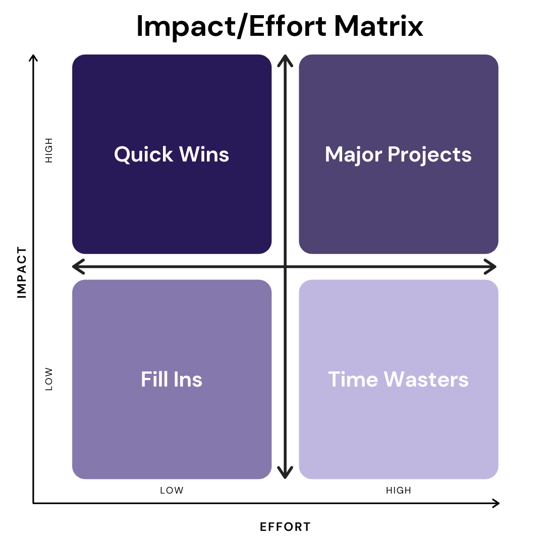
Above: A diagram of how an impact/effect matrix is formatted.
Cimone and Hannah developed questions for stakeholders relating to impact and opportunity/effort in order to facilitate a conversation on geography-based prioritization for decisions such as where to plant trees and allocate resources over time, as well as where and how to engage stakeholders in planting trees and connecting with community members.
Mapping Equity In the Tree Canopy
In order to better understand existing inequity related to Syracuse’s tree canopy, Hannah and Cimone first calculated tree equity using American Forests Tree Equity Score (treeequityscore.org). Tree equity is about ensuring every neighborhood has enough trees so that every person can reap the benefits that trees have to offer. Tree equity was calculated at the census tract level using social, demographic, and tree canopy cover data. Additional maps combined ground temperature data, with canopy cover, location of vacant lots, and community organizations. Data analyst Joanna Bailey and planner Cimone Jordan developed these maps, which Hannah and Cimone used to facilitate stakeholder conversations.
Areas with a low tree equity score have low tree cover and poorer air quality, disproportionately impacting vulnerable populations and people of color. High tree equity scores indicate good tree equity. To learn how tree equity score is calculated, visit https://www.treeequityscore.org/methodology/.

Above: Map created by Joanna Bailey showing tree equity score by census tract.
Cimone and Hannah leveraged Joanna’s tree equity map as well as additional maps (shown below) to lead a discussion about where and how to plant trees.

Above: Map created by Cimone Jordan showing land surface temperature, vacant lots by owner (Syracuse City School District, City of Syracuse, Land Bank, or privately owned), areas included in the Resurgent Neighborhoods Initiative, Blueprint 15 areas, and planned single-family home sites.

Above: Map created by Cimone Jordan showing tree canopy, vacant lots by owner (Syracuse City School District, City of Syracuse, Land Bank, or privately owned), areas included in the Resurgent Neighborhoods Initiative, Blueprint 15 areas, and planned single-family home sites.
Using innovation and data methods, employing maps and impact/opportunity prioritization, the team is engaging stakeholders in the planning process for the Urban Forest Master Plan in creative and effective ways. The team will continue to solicit stakeholder input through June and strives to roll out specific implementation strategies in each of the three areas in time for pilot projects in the Fall of 2021. In the meantime, stakeholders will continue to inform the conversation around implementation, discussing tree equity and canopy, education, and tree planting on private property. When the methods our team uses can be employed to effectively engage residents in the planning process, we call that a success.